Monday, July 29, 2019

Press Traverse Trail Report-- Women's solo FKT

The Press Traverse Trail is a combination of the North Fork Quinault River and Elwha River Trails that crosses Low Divide and takes you through several beautiful ecosystems. I began running at the south end at about 8:20am on Friday July 26th with the generous help of my boyfriend, who sent me off with much good luck and picked me up at the Elwha end. 

The day was cool to begin with but warmed up very rapidly and became sticky and muggy. The trail was delightfully clear and the sunlight was amazing filtering through the old growth cedar trees. The trail on this side of the mountain is rocky and you start climbing up to the Low Divide almost immediately, though lots of this section is very runnable. 


I switched up my hydration method this year because I knew there was a lot of water on the trail. I still carried a bit over a liter of water at a time but I used a Katadin BeFree filter my boyfriend gave me, which cut down on filtration time A LOT. There was a lot of trail work being done on the Quinault side and I was really happy to run into a couple of student crews; they were friendly and chatty and cheered me on as I trotted by. Thank you SO much for the hard work, the trail is looking SO AWESOME! 


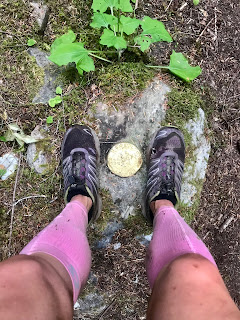
The Quinault River crossing (and all the creek crossings) are very manageable right now-- the river is only about knee high and was refreshingly cool. I started running into blowdowns around mile 12, though none were really terrible until the old slide at 13.25. I remembered it from last year and didn't give myself much time to remember how disconcerting it was to scramble across it. It is totally passable, though it would be tough with a backpack, I just don't particularly like creeping across slide plugs like that. There was a survey marker I don't remember running into when I was just about to the final climb up to the Low Divide and you can see that the trail was a little bit boggy in places from the condition of my shoes. Careful if you try to step around the boggy parts, there's a lot of Devil's Club growing along the edges.

There's no way else to describe the Divide than GORGEOUS! Last year I spent so much time exclaiming over the views and the colors and the waterfalls cutting down the sides of the mountains and I could have easily done the same this year but kept myself moving after a few snapshots. The little streams that form the headwaters of the river are perfect for soaking your feet or just refilling your water pack but you should expect to get your feet wet. 

I felt like I was on track for a pretty quick descent through the Elwha River Valley but the trail was quite different from last year. The salmonberry and thimble berry bushes are pretty overgrown right now and hid lots of hazards like rocks, tripwire branches, and lots of step-downs so I highly suggest you descend carefully. I took a couple of headlong falls and got pretty banged up through this section and the full-body experience continued for quite a while with lots of blow-downs from this previous winter. Some were really passable and easy to step over and others were rats nests of several trees piled up and blocking big parts of the trail. If you're ever in doubt of where the trail continues, look for the pink and yellow flagging tape that shows you where the trail continues. Don't get too distracted though, the old growth trees are stunning!
I regret not marking the mileage where I encountered one particular fall but it's along the easy rolling section after you cross the Elwha River (perfect place for a dip!). An old deadfall landed along the trail and broke in half, making a little gate you can pass through. It looked easy enough, just run alongside the old log until you get to the break but BE CAREFUL because there are several jagged broken branches along its length and I ran right into one, gouging my right shin and helping me get pretty creative with my language. The only other section I found a little sticky was the second Elwha crossing-- a footlog crossing that has been a little crunched by blowdowns. You can cross the river on foot if you need to at this point but the log itself is still intact, you just have to scramble a little to get on the log. The trail gets really gorgeous at this point and a little bit softer on the feet, which is nice after the rocky trail up and down the Low Divide.


This might be my favorite section of the trail, everything is fuzzy and green. The blowdown section slowed me down quite a bit so I pushed the pace as much as I felt was safe in order to finish well before dark. You'll exit the mossy section after a few miles and need to watch out for nettles and roses growing really thickly into the trail. Splash straight through the muddy sections because stepping to the side pretty much guarantees you'll get hit by one or the other. Once you're in the last 10 miles you'll start to see evidence of trail work.

I was having trouble smiling for the last few pictures because my legs were scratched and stinging and I was still grumpy from tumbling down the Low Divide but pushed myself up the last three inclines; I was looking forward to seeing my boyfriend and just... not running for a bit.

I had landed on my quad during one fall and that made the inclines really challenging but the trail is also beautifully clear and totally runnable. The end of the trail comes very shortly after the third incline and is downhill all the way out. I snapped a picture next to the trailhead signage and took a seat on the picnic table nearby for a little bit before tackling the 6.5 miles from trailhead to parking area below the washout. Be careful if you're doing this in the dark, which we did since I finished around 9pm, because there are lots of critters out there. We saw a few deer but also two cougars within 50 feet of us. 

My totals:
Garmin Forerunner: 45.2miles, 12:29:22 total elapsed time, 7,430 feet of gain, 6,782 loss
Strava: 44.73 miles, same elapsed time, 8,565 feet of gain, no reported loss

Thanks to my boyfriend for the cheerful sendoff at the beginning and welcome at the end, for stumbling around with me in the dark at the end, and hugging me so much even though I smelled like a bog monster! Thanks also to my dear friend Jessica for loaning me her InReach and keeping tabs on me while I ran.
Monday, October 1, 2018

Press Traverse Trail, Women's FKT

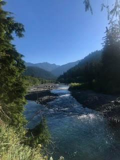
The Press Traverse trail is a combination of the modern North Fork Quinault River and Elwha River trails
which traces through much of the original Press Expedition’s route. The Traverse was first begun in 1889
in a push to discover the mysteries that lay behind the Peninsula skyline when viewed from Seattle. The
adventurers labored for six months, spending a large amount of time working near Sequim on an ill-fated
raft to carry their provisions south, before they finally emerged at Lake Quinault.
The trail curves like a backwards ‘S’ through the center of the Olympic National Park, cresting the Low
Divide where you can see the headwaters of the Quinault River. It covers approximately 46 miles of
remote terrain with approximately 7,144 feet of gain and 6,378 feet of loss (if traversed from south to
north). The trail is beautifully set up for backpacking over a period of several days, but Riquelle Weaver
and Carrie Espasandin decided to try their hand (feet?) at covering the distance as quickly as possible.


We gratefully accepted a ride from Riquelle’s fiance to the North Fork Campground on Friday,
September 28th and spent a restless night before dressing in the mist on the morning of September 29th.
Based on past reports of rocky trail and potential blowdowns, we chose to wait until 6:51 when the cloudy
morning lightened a bit.


The terrain is hugely varied along the trail, and we began by making our way through old growth cedars,
ferns, and stands of moss-cloaked maple trees. The river was steely gray with mists disappearing quickly
from its surface and settling instead on everything around it. The trail here was very wet and therefore
treacherous. We found ourselves frustrated, tip-toeing across otherwise fully runnable surfaces.
Especially tricky were the numerous bridges, slick as ice.


We were lucky to have found this weather window so late in the season. The leaves were turning,
mushrooms bursting through mosses and covering every available mouldering surface, and the stream
crossings were manageable. The clouds began to burn away mid-morning and we came across
handwritten notes left by some well-meaning trail maintenance crew (based on the shovel and pickaxe
tethered to a tree near the trail) warning of bees and re-stating that livestock was not permitted past a
certain point. We had no trouble with the bees, likely because of the late season and cool morning.


The trail cruises slowly up towards Low Divide and we found ourselves trotting along high on the
mountain sides above the River. The cedars were mostly gone by this point, replaced with sturdy
Douglas Fir.
Around 11:45 am and approximately 13 miles along the trail, we ran into our first major obstacle. A
rather notable slide had taken out a large portion of the trail and replaced it with a jumble of boulders
and timber. We squeezed through fairly easily with our running packs but I imagine it’d be a challenge
with a proper backpack. It’s a short scramble but I didn’t like it much, it seemed the plug was hanging
out over the actual cliff edge.
At least three times along the length of the trail we noticed small ceramic insulators bound to thick
gauge wire embedded in old trees. While we are aware that early settlers had homesteads in the
present day Park, some of these insulators were found at very precipitous points along the river valley.


We were a little nervous about river crossings so late in the season and after a hefty first rain, but our
fears were unfounded; the North Fork Quinault River was low and relatively slow. Nevertheless, we took
the precaution of finding a clear, sandy crossing in a wide spot along the River. We held hands for
stability and waded through knee-deep water to a beautiful backpacker’s camp on the other side, where
we paused to filter water. It’s not perfectly clear where the trail continues when you get to the other side
but you’ll find it if you bear left just after stepping into the trees.
The incline gets noticeably steeper as you press onwards on a well-manicured trail, aside from the
occasional downed tree. We hadn’t quite reached the peak of the Low Divide when we came across a
bronze marker, which we are accustomed to seeing at summits. We took a picture with it for good
measure. The headwaters of the North Fork Quinault trickle down from the many nooks and crannies of
Mounts Seattle and Christie which border the Pass.

We gave a great impression of Julie Andrews in the meadow scene of The Sound of Music, energized
by the amazing views. We lingered and took photos, splashed through the babbling streams, enjoyed
the stunted Silver Pines, and finally pushed onwards, eager to see the two lakes that occupy a saddle in
the Pass. Lake Margaret is the larger of the two lakes and we chose to sit on her southeastern tip to
enjoy the framed view of Mt Seattle while we lunched and changed our socks.
Our feet were bleached white and wrinkled like prunes from the drenching we’d had on the Quinault
trails as well as the numerous small crossings we’d had to splash through. We sat for longer than we’d
planned, allowing our feet to dry in the sun in the hopes they’d resist the effects of the 28 miles that lay
ahead of us. Finally, we lubed each toe and pulled on clean socks before lacing our feet back into wet
shoes.


The elevation profile shows a steady decline to the Elwha River Valley and we were not
disappointed. Finally, we had reached truly runnable trail!
We took advantage of the dry trail and fell quickly to the Valley floor, barely catching a glimpse of a
beautiful waterfall (Delabarre Creek?) tumbling off the opposite side of the valley as we careened around
switchbacks. We trotted along at a decent pace, squeezing between huge Douglas Firs that studded
this side of the Pass.
A rather large blowdown (Lat 47.734223, Long -123.533414) forced us to detour off trail where we
confused a game trail for the correct route. We took advantage and refilled our water at an ice cold
stream before attempting to reach the trail via bushwhacking. We were probably close but also gained
perspective on why it took the original band of men nearly three months to cover 40 miles of ungroomed
wilderness.
We picked up a few scrapes and bruises before popping out on the Elwha River just 30 feet from the
log bridge we were intended to use. It was about 2:30 pm and the sun felt lovely on our shoulders. We
doctored up our scratches in the backpacker’s camp on the north side of the Elwha River before
pressing onwards, aware of the precious time we had lost in our unplanned detour.


Bang out the miles was our new motto and we hammered them out like we were being paid to (Side
note: we found a nickel on the trail so…). The valley floor was relatively level and the trail defined and
easy to follow. We pointed out the biggest trees we saw and skipped over patches of chanterelles as we
ventured forward.
The forest had changed considerably. The men in the Press Traverse Expedition mentioned the
difference in their journals, though they had gone opposite our direction. The Quinault side of Low Divide
is more often drenched by humid air pushing in from the ocean than the Elwha side and the poor men
complained about how wet and decayed everything was  south of the Low Divide. Though they enjoyed
the enormous cedar trees, I can understand how their misery was magnified by traipsing through the
soggy rainforest of the lower North Fork Quinault River basin.
We had the opposite experience and marveled at the deep moss that framed the trail. Our feet were
pretty tender at this point and we commented how lovely it would be to just lay down in the cushy border.
We resisted, knowing we had a goal in mind. We were still trying to make up the lost time from the trail
detour.
Old growth forests are defined as natural forests (not having been logged, etc) that have developed
over a long period of time, at least 120 years. The trees we goggled at were several times older. It’s
unsurprising that we didn’t meet with any animals on this section of trail because we loudly admired each
towering tree we passed. The trail maintenance here was impressive-- some fallen trees had been
chopped through by hand! We passed a huge downed tree that someone had carefully market with pegs
for every ~50 years of life it lived. We counted over 550 years (someone had written 700) and we had
passed even larger trunks still standing.
Up to now we had gotten away with carrying only a liter of water each, relying on the many streams
dotting the trail on the Quinault side. There is still an abundance of available water on the Elwha side,
even when the levels are as low as we have remarked, but we began carrying more water to decrease
our stopping time and as insurance for any streams that may not have been running. I was happy
carrying about 2 liters.


The single track seemed to enjoy carving across the mossy hills as much as we did and we thanked the
creators of the trail for including these fun little twists and turns. We’d tried to avoid stepping in streams--
fairly easy on this side of the Pass-- but our shoes were still sodden from the Quinault miles and water
squished up between our toes at every step. Another sock change took place next to the Elwha, just
past a picturesque Hayes River Ranger Station cabin. We made some brief calculations regarding our
target time then bent our knees to the task again. It was 5 pm and darkness was not far off, especially
when cruising beneath the dark boughs of the forest.
We briefly visited the Elk Lick Lodge, one of two private fishing cabins still standing from the pre-Park
era. Due to its age, backpackers are encouraged to camp at least 100 feet from the cabin but it is worth
a look!
Back into birch trees and moss-draped maples, we beat feet down the compressed mud track, catching
brief glimpses of the teal-colored Elwha in the fading light. Darkness fell and the headlamps came out.
We were still in good spirits, though our feet ached and our knees protested the downhill we had enjoyed
since Low Divide. Don’t let the last bit of trail fool you! There are some serious inclines before you reach
Whiskey Bend trailhead.


While we were discouraged by the setback early on in the Elwha River Valley, we are proud to have set
a new women’s FKT of 14:33:34. We shouted in glee at the sight of the trailhead and crashed on the
nearby picnic table to rest our feet. Our ride was nowhere in sight, though they knew our location from
the InReach we had with us. As it turns out, we checked every report except road closures! We had a
nearly 7 mile walk to the barricade and our ride back home, bringing our total mileage for the day to 54.
We don’t encourage people to add on this mileage when attempting this thru-hike/run.


Sunday, January 3, 2016

Big baldy- Indian creek loop, Frank Church Wilderness

 I have been more than remiss! This summer (2015) I took an incredible week long trip into the wilderness and surprisingly came out in one piece! I had been reading tiny snippets about this loop all year and committed to it once I found detailed maps in the college library. Lots of the reports for this trail were outdated but I was informed that lots of work had been done recently. 

Here I want to state my first warning. The dirt road leading to the trailhead, near Snowshoe Summit, was the roughest I've ever driven in my car. I highly recommend at least all wheel drive and some clearance. It is a Jeep trail in places. 

I parked on the side of the track near the trailhead and searched for some time to find the trail while my dogs blitzed around the hillside. I finally found the trail by beginning at the trail marker and walking east near the road. 

Here's my second warning. Please have a good map and decent compass skills for this trip! Though I will say the entire first day I enjoyed a very clear trail. 

I only walked about 6 miles the first day, owing to the extended drive to the trailhead. The entire area burned about 16 years ago and much of the evidence remains. As a result, finding adequate campsites without widow makers (dead, standing trees) was difficult. The very first evening I set up camp on a saddle between Little Baldy and Pistol Lake. Beautiful, but blustery!

Both sunset and sunrise were stunning!

Day 2 was nearly the end of my trip! After passing the trail to Pistol Lake the main trail curves down a hillside to the east. Initially, I walked all the way to the dirt road at the bottom, perplexed that I hadn't found the continuation of my route. I spent about an hour perusing my map, having a snack, and browsing the hillside before deciding I would make one last effort to find my trail before spending the next few days at Pistol Lake. The trail is faint since it wends along the rocky hillside, but there it was! Leading me eventually into one of the sterilized areas from the old burn. Sometimes the fires can burn so hot that recruitment of new trees and plants takes an incredible amount of time. Seeds and spores can't survive the heat and even the soil composition is changed. 

This also means the trail is tough to pick out in places. Don't worry, it gets worse! Thankfully, the day was cool and relatively overcast so I didn't smell like a troll until later. The trail takes you along the rugged spine of the mountain until you reach Chilcoot Pass. The trail to the peak is still available and there used to be the remains of a fire lookout up there but I pressed on. 

Approaching the Pass, the Peak to the left. 

Chilcoot Pass signage. 

Coming down the pass was a little slick in places but I thought it was awesome to stumble upon a spring in the middle of the trail. It's a thin spring but the water was cool and delicious! And filtered, of course. The dogs and I sat here for lunch and enjoyed the green valley we were descending into. 

Today is the day I wish I had stopped earlier rather than later. There's a really lovely meadow I camped in on the way back and it would have been a great stopping place for today. It's to the left of the trail just before it joins up with a dirt road. I pressed on, wanting to make up the miles I hadn't done the first day. 


This is the trail as it leaves the dirt road heading to Pistol Rock. The trail is really bad here, with erosion washing out major portions. My dogs and I slid into one washout when we stepped onto the trail where it had been undercut. Be careful here!! The trail splits just after Pistol Rock and I took the split toward Big Baldy. The trail carried me across the spines of mountains and through stands of new Lodgepole Pines, but every flat tent spot had dead, burned-out trees looming over it. The day was hot and the trail was dry. My 2-liter camelbak sprung a leak and I lost all but half a liter. The dogs were exhausted and we took extended breaks as the day drug on, laying full out in the dirt to nap and rest our feet. We were all thirsty. The trail alternated between being visible but brutal, and nearly nonexistent but fair. Sometimes I had to backtrack to find the trail and often the only indicator of the trail was an old cut end of a log where trail crews in the past had cleared. I nearly turned around today. Buck Lake was close but as I drew near I made the mistake of focusing on a pond off the trail. I imagined that it had to be Buck Lake, ignoring the lack of trail. An easy thing to do when you're out of water. I rationalized that I knew where the trail was and I knew where I'd be down at the pond, so I descended about 800 feet and spent the night at a mosquito filled bowl with a muddy shored pond that gave me the water I needed to think straight. I had made a mistake going off trail. I got a little choked up and felt sick to my stomach. A voice inside told me to get it together and just fix it tomorrow. I did just that but only after a beautiful sunset and some much needed sleep. 


Day 3 broke and we were up early. The stress of the previous day, coupled with the thirst I had endured meant I hadn't eaten much. I was still concerned about getting back on trail and wasn't able to stomach more than a few bites from an energy bar. We climbed back to the trail and found it sheers off the spine to bend and twist steeply down a slide to the picturesque Buck Lake, where we rested for most of the morning. 


I smelled like I hadn't bathed in a month so I stripped down and stepped into the lake. I barely got above my ankles before the cold stopped me. I splashed about but drew the line at washing my hair. My scalp already felt tight enough to pop off my head. We rested in the morning sun for hours before slowly packing up and moving slowly towards Big Baldy, where I wanted to stay in the lookout. 

Let's take a closer look. 
Can you see the trail cutting through the green to the right of the slide? I'd hate to go up that trail. This section of the walk was quite beautiful. I walked through green mountains and out onto grassy hillsides which had once been covered in timber but was still recovering from the burn. I could see the lookout for nearly a mile as I came around a big bend in the trail. We were moving very slowly at this point, paws and feet sore and legs aching. Rounding Big Baldy was my favorite part of this trip. The surrounding mountains were exactly how I had pictured them to be: dark stands of trees broken by furry, grassy meadows. 
We were on a roll and continued trudging along the dusty trail. I kept looking up the length of Big Baldy, wondering if I'd be able to make it to the top, when I stopped dead in the trail. I heard water! Sure enough, a spring bubbled gaily down the mountainside just below me. We flopped down in the squashy moss and slept. This spot was tough to leave; I even contemplated setting up camp by this spring! I was finally able to eat a full meal, though a few bites were shared with my pups. 


When we finally stood up, it was clear none of us would be able to make an additional 1-mile, 1,000 foot climb to the lookout. We compromised by camping near another spring that delighted me by flowing through a miniature trough at waist height, so I didn't have to crouch to filter the next day! 

Signage for the lookout trail. 

Little did I know that I would have slept far better had I taken the trail to the lookout! But that's a story for the next blog. 

Thursday, January 29, 2015

Russia

 This winter seems to be dragging on longer than it should so I thought I'd give a culinary shout out to folks who spend more time in winter than any other season. Russian cuisine is fairly simple and robust, though a tad single-noted as far as I've experienced. Today's dish is called Rassolnik and it is literally a dill pickle based beef soup. I love dill pickles-- so much, in fact, that I used to get them for Christmas! This was an easy, fairly quick soup to make but I'll probably just eat a pickle if I'm craving this much salt again. 

Technically, the meat in this soup is beef or pork kidneys, but I used beef soup bones since my town doesn't generally have organ meats available. It is also, apparently, a favorite hangover cure in its homeland. 

Take beef or pork kidneys (or bones) and simmer them in water for at least 1 hr. Add a handful of barley after the water begins to simmer and stir on occasion to prevent burning. Vary your bones to water ratio depending on how much soup you'd like. 

After an hour, remove the meat and dice it into bite sized chunks. Replace meat in broth. Add 1-2 Tbsp salt. 

Dice 1 full cup of dill pickles and sautée them briefly in oil (2-3 minutes) before adding them and 1 cup of pickle juice to the broth. Dice 1 medium potato and add it to the broth. 

Sweat 1 chopped carrot, 1 chopped stalk celery, and 1/2 yellow onion (chopped) for 10 minutes. Add to soup. Add a bay leaf if you have one, it might help add some depth to the soup. Simmer an additional 15 minutes or until potatoes are soft. Serve with a spoonful of sour cream and additional dill to garnish (which I didn't have).